Land use denotes how humans use the biophysical or ecological properties of land. Land use is characterized by the arrangements, activities and inputs people undertake in a certain land cover type to produce, change or maintain it (Jansen and Di Gregorio, 2004). Human activities are a major factor contributing to change in ecosystems by the way we exploit its. It is well known that ecosystem provides a series of services and functions such as provision of habitat for biodiversity, but we mix place this opportunity for insecurity such as, banditry, kidnapping, cattle rustling and farmers-herders clashes and religious crisis.
This study concentrated on using space-based technology to analysed existing forests reserve and security surveillance in the federal capital territory. Forest related habitation for criminals hide out will be applied to Landsat Operational land Imager (OLI) imageries to assess usefulness of remote sensing and GIS for security purpose. ERDAS Imagine version 2014 was adopted for classification and Arc GIS 10.4 environments to process, manage, and analysis the raster and thematic datasets.
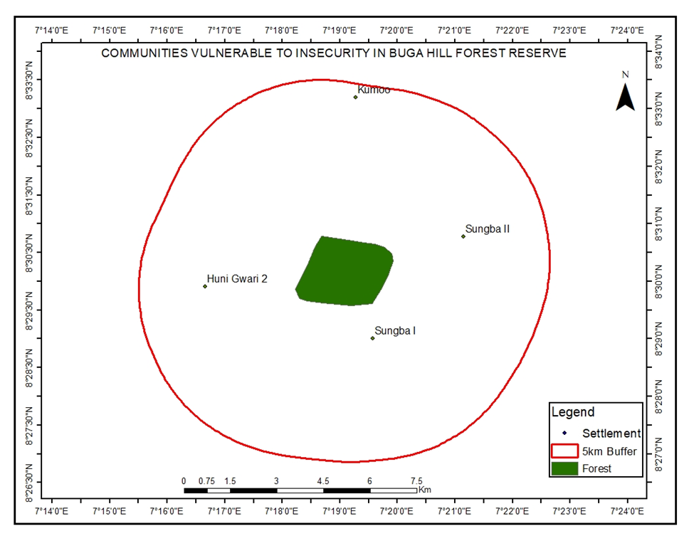
The parameters used in this research are: The Normalized Difference Vegetation Index (NDVI), land use/land cover (LU/LC), buffering and digital terrain model (DTM). It shows that 0.5 value in NDVI is forested area, while -0.08 value is other land cover. In the multiple buffer analysis shown that people leave in settlements for about 5 kilometres (km) away from the forest are more likely to be more prone to criminals’ attack than 10 km and 15 km settlements are the least attack to any form of insecurity. Land use/land cover map provides ranges of classes for operatives. Digital terrain model and coordinate points provided terrain and strategic location where security operatives can carry out needful operation.
Insecurity generally disrupts development of nations and societies. That is, where there is conflict there is often underdevelopment. Insecurity is a critical issue that has hampered industrialization and sustainable development in Nigeria and particular the Africa at large. Space Technology has been adopted in the developed World to combat the problem of insecurity, uproar and other related Crimes. One of the approaches of addressing the problem of insecurity is the use of satellite. It is important to note that the role a satellite can play is not limitless. This is because the work a satellite does depend on the payload it carries.
Finally, this report lays out series of recommendations and they are summarized as follows: There is need to periodically carry out surveillance forest monitoring using space-based technology of the forests. This would assist to monitor report and detect the movements, encroachers and other activities of the criminals in the forests. The government should establish a well-equipped military barracks/security posts around the forests and the military should regularly carrying out combat operations of the forests to flush out the criminals and destroy their bases and hideouts. The security forces should launch an attack on all the forests to ensure that the insurgents, armed robbers, thieves, unknown gunmen and any other criminals are dislodged. Forest guards should be trained and well equipped to effectively deal with any armed threat from any group, encroachment and other illegal/criminal activities. Adequate funds should be allocated to the forestry sector. This would enable the sector perform its duties and ensure that criminals and insurgents do not take over the forest reserves.