Nigeria is a multi-ethnic nation with the challenges of ethnicity, pressure groups and conflicts which over time have metamorphosed into Bokoharam insurgencies, kidnapping, banditry and Herders Farmers clashes, breaching security and becoming a threat to the nation. The rate of these activities in Southern Kaduna in particular and Northern Nigeria in general is alarming.
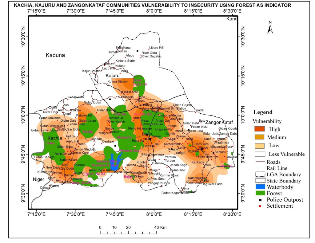
The purpose of the study was to ascertain whether there is any correlation between communities and forests in respect to attacks and crimes and understood the target, vulnerability relationship. Therefore, Communities at risk of insecurity in Kachia, Kajuru and Zangon Kataf in southern Kaduna were mapped and identified using satellite technology. The following datasets were used in the research: feature classes of forest, roads, water bodies and railways. Also used were coordinates of communities and police stations of the area.
Communities were buffered from one to six kilometres to the forest. Selection by location using query operations and analysis were then performed to determine the proximity of the Communities to forest in the study area. Proximity and vulnerability analysis was carried out to assess the category of vulnerability (high, medium, low) of Communities in the three local governments in southern Kaduna. Kernel density of the communities’ proximity to forest was generated, same overlaid with hotspots map of the same area also generated from armed conflict location and event data to produce maps of communities at risk in the selected local government areas in the southern Kaduna.
The result showed twenty-one (21) communities at one kilometer from the forest as highly vulnerable. These communities were distributed in the three LGAs with more concentration in Zangon Kataf, Kachia and Kajuru respectively. At two kilometers, forty-nine (49) communities were vulnerable. Seventy-five (75) communities were vulnerable at three kilometers, at four kilometers, 93 communities fell into medium category of vulnerability.
The research findings revealed that the closer communities are to forest the more exposed there are to attacks. The study therefore agreed to the findings and informed policy makers that by adequate police outposts, revisit and effective surveillance of hotspots, high, medium and low vulnerability locations would reduce or eradicate number of casualties from insecurity and would improve the standard of living of the people.
Analysis